Berwickshire Coastal Path 2024
Overview
Scottish Borders Council is seeking feedback on the current condition of the path and views on its future, including its alignment, taking into consideration the continued threat of erosion. The survey will inform the next stages of a project aiming to develop a longer term plan for the path which protects and enhances it whilst continuing to allow for adaption as and when required.
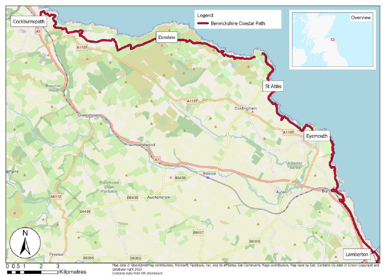
The Berwickshire Coast is known for its dramatic clifftop scenery, quaint coastal villages and rare wildlife and geology. The Berwickshire Coastal Path (referred to as the Coastal Path) winds from Cockburnspath to Berwick-upon-Tweed, connecting to many key points of interest for some 48 km.
Coastal erosion is a natural process, where the sea ‘eats’ away at the coastline, leading to cliff collapses. Sea level rise combined with harsh storms increase coastal erosion and flooding. Storms like the Black Friday Storm (1881), the Burns Day storm (1990) and more recently Storm Arwen (2021), have a devastating effect.
Future stages of this project will include design of high-level options for the future of the Coastal Path. The high-level options will be based on the information you provide, the vulnerability assessment, and the economic feasibility of the options.
We will be focussing on the following stretches of the Coastal Path (shown in the figure below):
● Cockburnspath to Dowlaw
● Dowlaw to St Abb’s
● St Abb’s to Eyemouth
● Eyemouth to Lamberton
Why your views matter
Your responses will inform the future of the Berwickshire Coastal Path.
Thank you.
Areas
- All Areas
Audiences
- All staff
- Amenity groups
- Architects/designers
- Built heritage groups
- Businesses
- Carers
- Catering businesses
- Children and Young People
- Civil and public servants
- Community councils
- Community group
- Councillors
- Developers/investors
- Development planning key agencies
- Education institutions
- Elected Members
- Employees
- External councils
- Homeless people
- Housing associations
- Jobseekers
- Landowners
- Lesbian, Gay, Bi-sexual, Transgender people (LGBT)
- Licence holders
- Low income households
- Men
- Minority Ethnic groups
- Older people
- Parents/carers
- People with disabilities
- People with long term conditions
- Planning consultants
- Professional bodies
- Professionals
- Residents
- Road users
- Scottish Government departments
- Services/Utilities
- Sports group
- Students
- Taxi Licence holders
- Teaching/education staff
- Third Sector
- Transport groups
- Visitors
- Voluntary Sector
- Volunteers
- Women
Interests
- Community Resilience
- Natural heritage/open space
Share
Share on Twitter Share on Facebook